Episode 9
Great Expectations

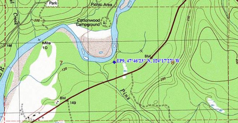
Lat: 47º46’23” N, Lon: 124º17’27”W
Expectations, from a surveyor’s perspective, can lead to self-fulfilling prophesies. For instance, believing it would be pointless to search for a hemlock post set the better part of a hundred years ago in woods that have been logged over since, increases the likelihood that the search will turn up nothing. Conversely, if you think, “I believe there is a chance…” experience shows it is much more likely your search will be successful. One day in 1978, I’d become a True Believer. See also, Episode 8, “Due Diligence and the Axe”
General Land Office (GLO) surveys performed on the Olympic Peninsula mostly during the last half of the 19th century, resulted in a network of 6-mile x 6-mile square “Townships” (usually) consisting of 36 one-square-mile sections. Modern day crop circles notwithstanding, evidence of these surveys are easily seen from overhead, especially in rural areas. Check it out on your next airline flight.
Sometimes, a surveyor’s task is to recover physical evidence of these surveys on the ground. The trouble is, such evidence is often obscure and faded or just plain hard to find due to the raw passage of time and the environment in which the monuments in question are located. On the Olympic Peninsula, stone monuments were sometimes set at section and quarter corners, but not often. I once remarked to a colleague working in the northeast corner of the state, where stone monuments were more commonly used, that he was lucky to have so many original stone monuments to search for, as they don’t rot away to dust, like wood posts do. He agreed, but only up to a point: “Yeah, but it’s no fun searching for a stone monument in a rock slide.” Think of the warehouse scene in Raiders of the Lost Ark.
Ironically, the field search begins in the office by collecting survey records, especially those connected with the original GLO survey. Those records are available online from the United States Bureau of Land Management, Oregon State Office. For a given township, they consist of one or more survey plats (or maps) of the survey and the field notes upon which the plat is, in part, based. Both provide clues about the topography, locations of water courses and other significant features such as monuments’ proximity to homesteaders’ cabins and such. Surveyors are also interested in knowing if a particular corner monument has ever been found after the original survey was completed. Records of subsequent perpetuations of a corner monument by credible parties is valued evidence, indeed. These records have many sources: Timber companies, land management agencies such as the U.S. Forest Service, and the Washington Department of Natural Resources, to name only a few. County Engineers are also a good source of information.
The surveyor then compiles and analyzes this information. Existing corners (monumented corners that have been authenticated) are located in the field. Lines between authenticated corners are run and locations of pertinent topographic features mentioned in the field notes are mapped using precise survey methods and compared to the locations reported in the original survey’s field notes. Search positions for intervening corners that are missing are developed from all of this information. The bearings and distances from the nearest survey point to the search positions are calculated, and sketches of the search area, including bearing tree descriptions and monument information from the original field notes, are prepared.
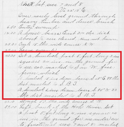
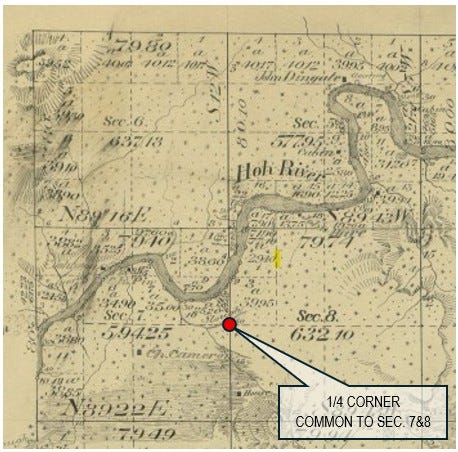
Still a rookie chainman on May 5, 1978, I was to become a True Believer, both in Frank E. Semon, the GLO surveyor who had gone before us, and in the methods we used in our work. We were searching for the 1/4 corner common to Sections 7 and 8, on the opposite side of the Hoh River from the Cottonwood Campground. After leaving the truck in a pull-off on Highway 101, we headed north for about 300 yards to one of our survey points. The crew fanned out, looking for signs of the original survey. At our survey point, I pulled out my copy of the search diagram, set my Silva Ranger compass for the bearing to where the corner monument should be, and paced off the distance shown on the diagram. Consulting the diagram again, I dialed in a bearing of S 48º E, per the record, to one of the bearing trees. Miraculously, there was an old, rotted 30” hemlock stump right on line, about 60 feet away, which comported well with measurement recorded in the original survey’s field notes. I walked over to this stump, took one swing with my machete to cut away at the rotten wood. Doing so exposed scribe marks! This was one of two bearing trees marked by the original survey crew in 1893. I was amazed. This surveying stuff really works, I thought. High-fives all-around!
From the “First Tour” with DNR, 1976-1979