Episode 7
"It's only the top six inches"


N 47º56’22.82” - W 124º33’40.80”
During World War II, Quillayute airport, then a Naval Auxiliary Air Station, was a training base for US Naval and Army Air Force pilots and crews. Local legend describes how one of the pilots from the base flew a P-40 under the Highway 101 / Calawah River bridge just north of Forks. By the time I saw the airport, in the fall of 1976, it was a little used emergency and civil aviation airstrip.
Newly hired, I was the lowest form of life on the crew: a “rear chainman” or Engineering Aide 1. As such, I was also the lowest form of life in the Department of Natural Resources: even temporary summer interns got paid more than I did. Still, it was a full time-permanent position, and I was thrilled to have a job doing what I wanted to do most: Surveying. Although I was greener than the Sitka spruce, scotch broom and blackberry vines that were encroaching upon the now sleepy airport, I was full of enthusiasm.
In the days before the Global Positioning System, we relied on National Geodetic Survey triangulation stations to control our cadastral retracement surveys. One of these stations, NGS “Quillayute,” was located conveniently close to the project, near the intersection of the airport’s two main runways. We’d be occupying this station and would use NGS “Gunderson” as our initial backsight, which was about 8.25 miles away to the northeast on the summit of Gunderson Mountain. As the distance to “Gunderson” was so great, we had to use a more rigorous observing procedure than was normally called for. Tom, our “gunner” would need to collect 8 ‘sets’ of angles, totaling 16 observations on both the backsight and foresight, or a total of 32 readings. Each of the 8 sets had to agree to within plus-or-minus 10 seconds of arc, and no one set could vary by more than plus or minus 5 seconds from the overall mean of all 8 sets. These standards were quite difficult to achieve at times, due to interference caused by “scintillation” or heat waves—the effects of which are more apparent at the 30x magnification provided by the T-2’s telescope.
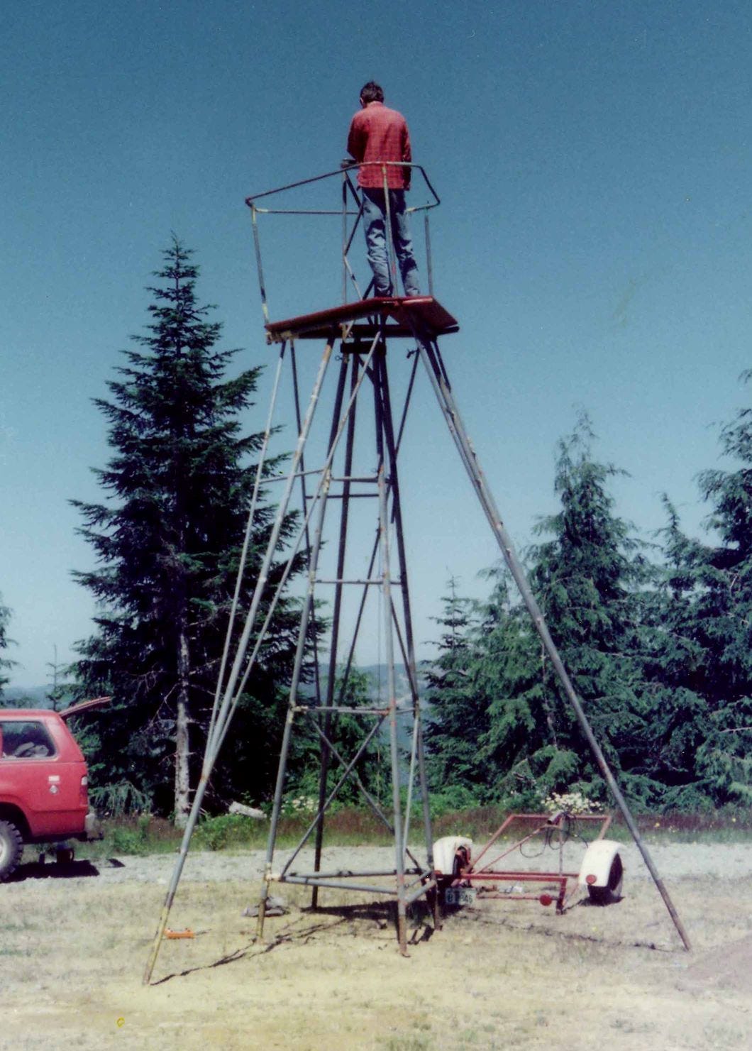
Sitka spruce grows fast at the airport. It’s not unusual to see growth rings an inch or more wide, and leaders up to three feet long. Consequently, with the passage of time, “Quillayute” and “Gunderson” were no longer directly intervisible—at least not without some considerable work on our part. First, we had to clear a path by hand through dense scotch broom, 10 feet wide by 150 feet long, from the paved taxiway to the monument, so we could set up a 20-foot tall “Bilby” tower over it. This would enable us to see over the spruce that were blocking the line of sight to Gunderson Mountain. The tower, which we’d towed here from the DNR compound near Olympia, consisted of two parts. The inner most portion was a 15-foot tall, rigid, three-sided affair, about 6 feet wide at the base, tapering to 18” wide at the top. Its three legs were telescoping and could be driven firmly into the ground with a sledgehammer. The outer portion was a tripod, also about 15 feet tall, with an 8-foot diameter platform at the top, and through which the inner structure could protrude---with the help of a 5-foot tall triangular extension that was later bolted to it. The tripod included some very fragile looking “safety railings.” Once the thing was set up, the inner and outer structures are independent of each other: they do not touch. The theodolite could therefore be mounted to the inner structure, and operators could walk around it on the outer structure’s platform without disturbing the instrument.
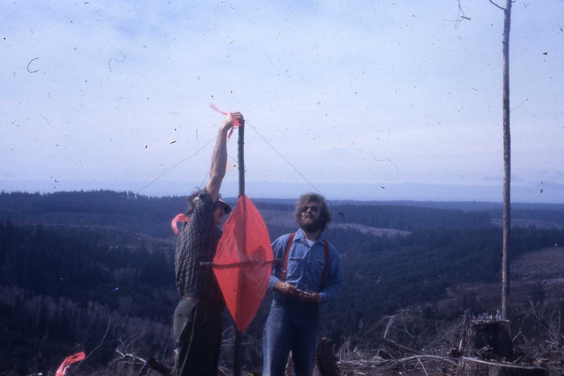
Meanwhile using chain saws, we had to clear a slot through the trees at “Gunderson” along the line of sight towards “Quillayute.” Once that was done, we built and set up a target signal (a cross-shaped framework constructed of native materials and lath, to which we affixed a 3-foot diamond of fluorescent fabric) at station “Gunderson.” Finally, all was ready.
At “Quillayute,” Tom climbed up one of legs of the outer tripod to the platform at the top. Next, he mounted the theodolite, a Wild T-2 with an inverted image telescope, to the inner structure. We had some difficulty getting the instrument centered over the monument because its optical plummet was not designed to focus on a monument that was 20 feet below. We were forced to use an oversized plumbob for centering. Now plumb and level, Tom turned the exquisite Swiss optics towards “Gunderson.” “Yeah, I can see it, but the top 6 inches of a spruce is on line,” he said. Gary and I joined him on the tower and took a look for ourselves. There was no getting around it: there was a short section of spruce leader was partially obstructing the target at “Gunderson.” We decided it needed to be removed.
Tom figured he could look through the telescope and thereby guide us to the offending tree by radio. So, Gary and I got into the Travelall, and drove to the other side of the airport, about a quarter mile away. The trees there were much larger than we had anticipated: they were 4 feet and more in diameter but had limbs all the way down to the ground. As we approached the base of one of these trees, Tom radioed, “That’s IT!!” I am not sure how he could have made this determination since we could not see the tower from where we were standing, but I was determined to give it a go and started up the tree in question. Initially, it was like climbing a ladder, and I felt pretty secure: the limbs were immense—6 inches in diameter at least, and the climbing was pretty easy. Up and up I went, until I could no longer see the ground for all of the limbs. At this height, I could wrap my arms completely around the tree, but the limbs were getting much smaller and springier. Looking up, I figured I had another 50 feet to go, and I was at least that far, and maybe farther, off the ground. I was wearing my OSHA approved hard hat though. Sizing up the situation, I yelled down to Gary who had the radio: “Tell Tom he can raise his tower! I’m coming down!” Well, we did raise the tower, Tom got his eight sets of angles and we began our four-mile march West from NGS “Quillayute” to the sea.
From the “First Tour” with DNR, 1976-1979